State DOTs employ lane reversals as Dorian approaches
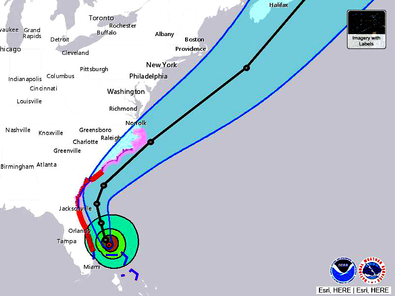
One of the strongest storms to strike the Atlantic is making its way toward the U.S. coastline. Although direct landfall is not forecast, Hurricane Dorian is expected to brush the Florida coastline Tuesday evening, traveling north toward Georgia and the Carolinas, possibly Virginia.
In preparation for the massive storm, state departments of transportation have taken measures, including toll suspensions and lane reversals.
#HurricaneDorian has now generated 10 times as much Accumulated Cyclone Energy as the other 4 Atlantic named storms of the 2019 Atlantic #hurricane season so far. Dorian has been long-lived & intense, while the other storms were short-lived, and only Barry became a hurricane pic.twitter.com/jsMuT6Pl3w
— Philip Klotzbach (@philklotzbach) September 3, 2019
Florida
According to the National Hurricane Center, Dorian is expected to “move dangerously close” to the Florida eastern coast on the evening of Tuesday, Sept. 3. A Category 2 storm as of 2 p.m. ET, the National Hurricane Center projects Dorian to maintain its strength as it skims the eastern coastline through Friday, Sept. 6.
A hurricane warning has been issued for Jupiter Inlet, just north of West Palm Beach, to Ponte Vedra Beach, which is just east of Jacksonville. The Florida coastline from Jupiter Inlet down to Deerfield Beach is under a tropical storm warning, with the southern-most tip of Florida largely spared.
Gov. Ron DeSantis has directed the Florida Department of Transportation to suspend tolls on the Turnpike Mainline and other selected toll roads, including:
- Alligator Alley.
- The Turnpike Mainline (SR 91), including the Homestead Extension (SR 821).
- Sawgrass Expressway (SR 869).
- Beachline Expressway (SR 528).
- SR 417 – Eastern beltway around Orlando from I-4 in Osceola County to I-4 in Seminole County.
- SR 429 – The Daniel Webster Western Beltway from I-4 in Osceola County to U.S. 441 in Apopka.
- I-95 Express Lanes.
- I-595 Express Lanes.
- I-75 Express Lanes.
FDOT will monitor traffic flow to determine whether or not to open the shoulders for travel along major highways. As of publication time, no bridge closures had been reported. As of Tuesday afternoon, all available lanes were open, including eastbound lanes.
Nearly a dozen counties have issued mandatory evacuation orders, with several other counties issuing voluntary evacuations for residents in low-lying, flood-prone areas. A list of up-to-date evacuation orders can be found here.
Georgia
The National Hurricane Center expects Dorian to reach near Georgia’s coast Wednesday night and Thursday as a Category 2 hurricane. A hurricane watch and storm surge warning is in effect for Georgia’s entire coastline.
On Tuesday morning, Gov. Brian Kemp issued a mandatory evacuation order for everyone east of Interstate 95 in Bryan, Camden, Chatham, Glynn, Liberty and McIntosh counties. Beginning 8 a.m. on Tuesday, contraflow will be used on Interstate 16. All lanes from Savannah to U.S. 441 in Dublin will be used only for westbound traffic.
Westbound travelers may exit I-16 at the following locations:
- Exit 143 at SR 30/US 280 (Exit to Pembroke at Ellabell, Ga.).
- Exit 116 at SR 73/SR 301 (Exit to Statesboro and Claxton at Metter, Ga.).
- Exit 104 at SR 23/SR 121 (Exit to Metter and Reidsville at Metter, Ga.).
- Exit 90 at SR 4/US 1 (Swainsboro, Ga.).
- Exit 71 at SR 15/SR 78 (Exit to Soperton and Adrian at Soperton, Ga.).
- Exit 67 at SR 29 (Soperton, Ga.).
- Exit 51 at SR 31/US 319/US 441 (Dublin, Ga.).
A crossover on I-16 at SR 26 (MP 38) in Laurens County will direct traffic back to regular westbound lanes prior to arrival in Macon. All westbound exits will remain open after Dublin.
Shoulders on interstates are reserved for emergency vehicles only.
GDOT also announced the closure of the Sidney Lanier Bridge on U.S. 17/SR 25 in Glynn County and the closing of the Talmadge Memorial Bridge on U.S. 17 in Savannah-Chatham County. Those closures begin at 8 p.m. on Tuesday, Sept. 3.
Also, GDOT will remove barriers and lane closures in place for the long-term Interstate 75/Interstate 16 Improvements Project only along Interstate 16 from Spring Street to its junction with Interstate 75 in Macon-Bibb County.
Carolinas
Hurricane warnings are in effect for areas north of Edisto Beach, S.C., to South Santee River, S.C. A hurricane watch is in effect north of Ponte Vedra Beach, Fla., to Edisto Beach, S.C.; north of South Santee River, S.C., to Duck, N.C.; and Albemarle and Pamlico Sounds.
Dorian is forecast to reach South Carolina’s coast Wednesday night and Thursday, moving near or over the North Carolina coast late Thursday. The storm is expected to maintain Category 2 status through Friday.
On Sunday, Sept. 1, Gov. Henry McMaster issued mandatory evacuation orders for coastal areas in the state.
Gov. McMaster also order the South Carolina Department of Transportation to reverse the direction of traffic along certain evacuation routes, which went into effect on Monday, Sept. 2.
At Hilton Head, one lane is reversed to create three lanes traveling west on U.S. 278 at the intersection of the Spanish Wells Drive and Moss Creek Village Drive. This reversal is approximately 2 miles in length.
From Charleston to Columbia, a full, four-lane reversal on I-26 in Charleston begins at the interchange of I-26 and I-526. The full reversal continues west until the I-26 crossover to I-77 just outside Columbia in Lexington County.
North Carolina Gov. Roy Cooper requested a federal emergency declaration on Monday, Sept. 2. According to a news release from the governor’s office, a mandatory state evacuation order was issued for “vulnerable coastal areas,” which goes into effect at 8 a.m. on Wednesday. The evacuation order applies to barrier islands along the entire coast.
As of Tuesday afternoon, no major road closures have been reported in North Carolina.
Virginia
Gov. Ralph Northam declared a state of emergency on Monday, Sept. 2. According to the National Hurricane Center, Dorian may reach the southeastern tip of Virginia by Friday morning as a Category 2 hurricane.
With the storm’s path proving to be unpredictable, Dorian may veer further away from Virginia by Friday. As of Tuesday afternoon, no evacuation orders or major road closures have been reported in Virginia.
“Hurricane Dorian is a serious storm, and current predictions indicate that it may affect parts of Virginia,” Northam said. “I am declaring a state of emergency to ensure that localities and communities have the appropriate level of assistance, and to coordinate the Commonwealth’s response to any potential impacts from Hurricane Dorian. I encourage Virginians to take all necessary precautions to make sure they are prepared as well.”
Monster of a storm
As of 2 p.m. ET on Tuesday, Sept. 3, Dorian is a Category 2 hurricane located approximately 105 miles east for Fort Pierce, Fla. On Sunday, Sept. 1 Dorian reached Category 5 status with maximum sustained winds of 185 mph, making it tied for the highest sustained winds at landfall in the Atlantic when it struck the Bahamas. The 1935 Labor Day Hurricane that struck near the Bahamas and the west coast of Florida also reached winds of 185 mph at landfall.
Dorian is also the strongest storm on record in the Atlantic to reach 185 mph maximum sustained winds this far north, according to Philip Klotzbach, meteorologist at Colorado State University specializing in Atlantic basin seasonal hurricane forecasts. Regarding minimum central pressure of 910 hPa, it is only the ninth lowest pressure in the Atlantic basin.
Related News