Natural disasters causing highway closures across nation, including I-70 in Colorado
Earth, wind, fire and water are all causing problems on highways across the U.S., with a closure of I-70 in Glenwood Canyon, Colo., being the most significant.
Natural disasters are ramping up in July. On the West Coast, wildfires are blazing and winds are blowing the smoke as far as New York City. In Colorado, rainfall is increasing the risk of mudslides in certain parts of the mountainous state.
Mudslides close Interstate 70
As of 10 a.m. local time, the Colorado Department of Transportation was reporting the closure of a portion of Interstate 70.
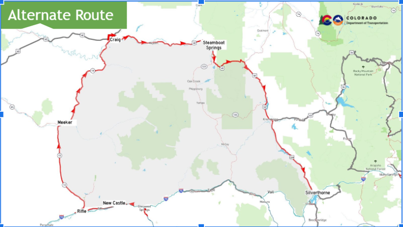
Specifically, I-70 in Glenwood Canyon is closed at Exit 87 (West Rifle), Exit 109 (Canyon Creek), Exit 116 (Glenwood Springs) and Exit 133 (Dotsero), due to flash flooding potential for the Grizzly Creek burn scar. Local eastbound traffic on I-70 is open east of Exit 109, but motorists should expect delays.
Motorists traveling eastbound on I-70 should take CO 13 Rifle to Craig, east on U.S. 40 to Steamboat over Rabbit Ears Pass to Kremmling down CO 9 to Silverthorne. Westbound travelers need to reverse the eastbound detour.
Last August, the Grizzly Creek Fire burned more than 30,000 acres in Glenwood Canyon. That fire forced the closure of I-70 for two weeks. Consequently, affected areas were scorched, destroying all vegetation and leaving behind only soil. Such conditions are ripe for mudslides during heavy rain events.
This marks the second time I-70 has been closed in Glenwood Canyon this month. Earlier in July, the interstate was shut down in both direction between Dotsero and Rifle. Mudslides were the cause of that closure as well.
CDOT is also reporting the closure of CO 14 in both directions between Rustic (mile marker 92) and Cameron Pass (mile marker 66) due to severe flooding in the area. There is no expected time of reopening.
Check COtrip.org for the latest road closure information.
West Coast wildfires
Wildfires in California and Oregon are burning hundreds of thousands of acres. Despite the situation, neither state is reporting significant road closures.
Near the California border in Oregon, the Bootleg Fire has burned nearly 400,000 acres as of publication, making it the largest wildfire in the U.S. this year so far. However, the Oregon Department of Transportation is not reporting any highway closures in the area, highlighting how vast the rural terrain is in southern Oregon.
The Bootleg Fire is only the fourth largest wildfire in Oregon history, succeeded by the 2012 Long Draw Fire (nearly 560,000 acres), 2002 Biscuit Fire (500,000 acres) and 2014 Buzzard Complex Fire (nearly 396,000 acres). The Bootleg Fire will likely surpass the Buzzard Complex Fire this week. Smoke from the Bootleg Fire is visible as far away as New York City.
However, ODOT is reporting the closure of a portion of OR 224 in both directions east of Estacada from Promontory Park to Ripplebrook Road at mile marker 31. FS Road 46 is also shut down. That closure has been in place for months as crews continue to clean up waste and debris from the Labor Day 2020 wildfire.
For the latest road closures in Oregon, visit TripCheck.com.
The National Wildfire Coordination Group is reporting about two dozen wildfires burning throughout the state of California. The largest active wildfire is the Beckwourth Complex at more than 100,000 acres. The Creek Fire has burned nearly 400,000 acres but is at 100% containment.
Meanwhile, the nearly 40,000-acre Tamarack Fire in Markleeville, Calif., has shut down Highway 89 at the intersection of Highway 4. Highway 4 is open west of the Highway 89 and Highway 4 junction. That is the only wildfire-related closure being reported by Caltrans’ QuickMap. LL
Related News